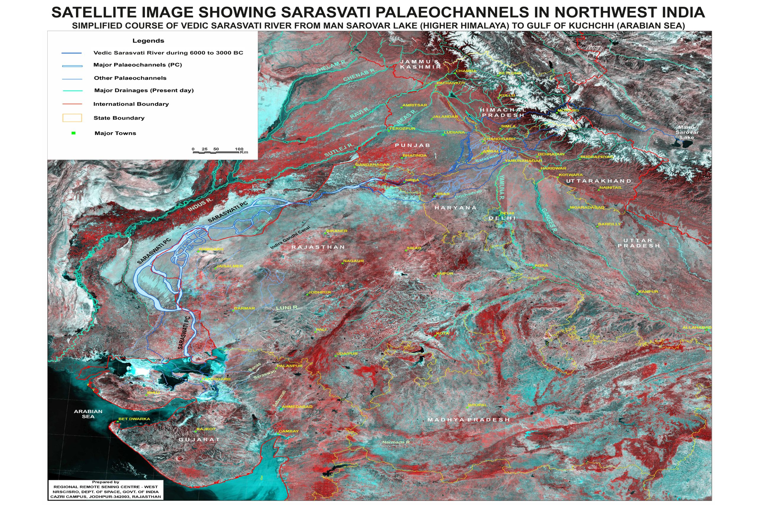
This article provides a fact-based timeline of how modern science—through satellite imaging, geology, archaeology, and hydrology—has uncovered compelling evidence for the historical existence of the Saraswati River, once considered a mythical river which disappeared meeting ganges at Allhabad Triveni Sangam.
Source:https://bhuvan-app1.nrsc.gov.in/saraswati/
2002 – ISRO–NASA Remote Sensing Study
-
Scientists from ISRO and NASA used Landsat and IRS-1C satellite data to identify subsurface river channels beneath the Thar Desert.
-
These channels traced a course from the Himalayas to the Rann of Kutch, closely matching Vedic descriptions of the Saraswati.
-
This was the first major scientific study linking satellite imagery with Vedic geography.
2003–2006 – Mapping by GSI & ISRO
-
The Geological Survey of India (GSI) and ISRO confirmed the presence of paleo-channels, ancient dried-up river beds, through remote sensing and ground surveys.
-
Studies suggested that the Sutlej and Yamuna once fed into this river, making it a large Himalayan-fed system.
-
The tectonic shifts that diverted these tributaries likely occurred around 2000 BCE.
2006–2010 – Archaeological Correlation
-
Excavations at key Harappan sites like Rakhigarhi, Kalibangan, and Bhirrana showed:
-
Dense urban settlements along the buried river course.
-
Artifacts consistent with Indus Valley civilization (pottery, seals, fire altars).
-
-
These finds validated that a major civilization thrived along this now-dry river.
2015 – Groundwater and Sediment Studies
-
A joint effort by Kurukshetra University and the Central Ground Water Board (CGWB) involved drilling across Haryana.
-
Found deep freshwater aquifers and fine sand deposits, indicative of an ancient riverbed.
-
These were dated to around 6000 years ago, confirming that the river had once been active.
2017 – Official Government Acknowledgement
-
The Ministry of Water Resources, Government of India, released a detailed report identifying the historical course of the Saraswati River.
-
The river’s route was traced through Himachal Pradesh, Haryana, Rajasthan, and Gujarat, ending in the Rann of Kutch.
-
The government acknowledged the Ghaggar–Hakra river system as the most likely remnant of the Vedic Saraswati.
2021–2023 – 3D Imaging and LIDAR Studies/h5>
-
Indian researchers used 3D subsurface imaging, LIDAR, and geoseismic modeling to further confirm the buried channels.
-
New studies supported the theory that major tectonic events diverted the Sutlej and Yamuna, leading to Saraswati’s gradual decline.
-
The region’s archaeology, hydrology, and sediment profiles all align with a once-mighty river system that disappeared over time.

